Barbour Brook State Forest
The joy of blogging for me derives a great deal from the exploration of new places. To find a new forest or trail (or, in many cases, a trail segment) online, on a map and then, of course, to immerse myself in the nature and ecosystems to be found there. So far, my hikes throughout different corners of Central New York and the Finger Lakes have been quite rewarding in their own right, yet always leaving me the desire to see more. This is a region rich in wildlife and history, which often overlap in interesting ways. In this part of the state, the land has been virgin wild first, then settled, logged, farmed, industrialized, abandoned, resettled again, and, after centuries of different uses for different peoples, appreciated and protected for outdoor enthusiasts like myself to enjoy.
Central New York is "sandwiched", in a sense, between the glacially carved famous Finger Lakes region to the west and the foothills of the Catskill Mountains to the southeast. Winding over 500 miles across this part of the state is the Finger Lakes Trail, mentioned and visited in older blog posts. The FLT does eventually journey to a connection with the Long Path, which the most ambitious long-distance hikers could take all the way to its junction with the Appalachian Trail in southeastern New York. As that is not a feat I could possibly undertake at this stage of my life, I've become more interested in hiking the FLT in segments, not necessarily in order.
Before this February 2022 late winter hike, the farthest east along the FLT I had ever traveled was in Pharsalia Wildlife Management Area, located in Chenango County some thirty-odd miles southeast of Syracuse, NY. The original goal of this particular newer hike was to reach a rocky outcropping summit of sorts described in a Wegmans Passport Hike guide booklet. At the risk of spoiling the ending of my retelling here, I must admit I never made it to the "summit" because of deteriorating weather conditions and time constraints, but I did, however, reach some interesting rocky hillsides, as we'll see later. This was also considerably closer to the western Catskills, which meant the many hills were steeper and the descents to valleys cut by streams just a bit more jagged and plummeting.
Barbour Brook State Forest, one of many puzzle piece-like parcels run by the DEC in this area, make up a swath of land, totaling over 11,000 acres known as the "Masonville Complex" (I know: it sounds more like a building than state wild lands). The forest I picked to hike on this outing is named after Barbour Brook which runs through the southernmost portion of the property. There are two other named streams of significance which the FLT crosses in this forest: Steam Mill Brook and Dry Brook. I never made it to Dry Brook or the lean-to that is said to exist near it: but that fact alone entices me for a return visit in the warmer months. Barbour Brook Forest also happens to be located in Delaware County, just past its shared border with Chenango County. This is territory east of the city of Binghamton, NY.
I took my family's one-year-old puppy dog with me on this hike (she loves the exercise and the chance to sniff new ground). I found a section of the FLT, completely new to me, naturally, that crosses NY Route 8 just south of the tiny hamlet of Masonville. The drive out here from Syracuse showed this is fairly remote country, with sparse houses and mostly farms or large privately-owned wooded parcels. It also took about 1 hour and 40 minutes to get to the trail head by car, so this ended up being a hike further away from where I live (which means more driving time and potentially less time to actually hike, if not timed correctly). One good thing down this way was that the snow from previous winter storms had all melted, unlike back closer to home where the snow pack is still thick at this time of this writing. I enjoy snowshoeing once in a while, but hiking without snow or ice remains my preference.
Fortunately, the trail head was easy to locate and the parking off of Route 8 excellent. It appears the lot could easily fit five or even six cars, but given the location, it's unlikely this place gets much foot traffic. I was the only one here today. At the trail entrance was a sign post with a map of the Masonville Complex and some written pamphlet information about the place. Oddly enough, no trails were shown on the map, as least not that I could see.
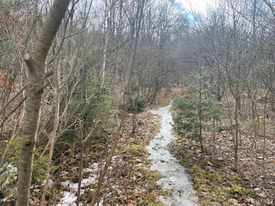
The Finger Lakes Trail, heading eastward, had some leftover ice across the first few meters but then it was dry hiking into bare deciduous hardwoods and past young conifers.
Turning past the small stand of birches, the real winter views of other foothills began. I appreciated being here at this time of year as I imagine these hills would be harder to glimpse through full green foliage.
As quickly as the path pitched upward, it descended into a small, very scenic valley traversed by dirt Steam Mill Road and its namesake creek.
The brook, in my opinion, was undoubtedly gorgeous, and a real high point of this hike that I never anticipated from basic topographic maps of the area (treacherous crossing aside). And once I landed on the other side with the dog (who was loving every second of this and even making the risky crossing look easy), I was awarded by the site of what appeared an active beaver dam. My scrambling over ice wasn't done yet, though. I had to navigate uphill and around some more icy sheets, although these ones smaller. Hiking up the next hill, east side of Steam Mill Brook, was a moment of more peaceful meditation until the trail joined an unnamed jeep trail which also doubled as a snowmobile route.
It seemed this snowmobile corridor had more frozen puddles and dirt than any snow. The FLT then re-entered the woods after the wider trail split into two directions: one to the right and the other the left. At any rate, I was happy to be back on a smaller, more primitive footpath. This rock jutting out from deep in the ground would hint at things to come: For the next quarter of a mile beyond the moss-painted rock, the trail continued its unabated wandering through more mixed forests and an increasingly rock-strewn forest floor.
The final stretch of trail before I turned back featured some lovely old rock formations. I initially thought these were the ones labeled as one of the passport hikes, but it turned out that place is much further ahead. That will have to wait for another visit here.
These rocks made a good place to stop and eat a snack before venturing back to the car. By this point, the weather was quickly turning colder and cloudier from an ensuing front. The total trip length of this hike was just a bit over 3 miles. It seemed longer to me, possibly because of the trickier footing and the problematic creek crossing. The total elevation change was 575 feet. This was a hike I thoroughly enjoyed, even with its challenges. The forest and topography here was simply beautiful, and I yearn to return either during summer or autumn months. Essentially, this hike hit all the right notes for me with views, water crossings, deep forests, and an excellent well-blazed trail.


Comments
Post a Comment